

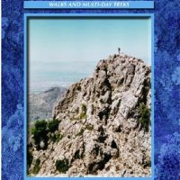
The HRP footpath skirting up Pic d'Anie
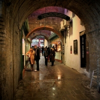
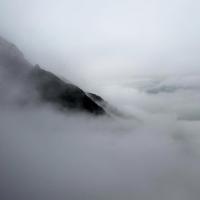
WE drive up hairpin bends to Lescun, a hamlet tucked in a high fold of the Pyrenees – a really beautiful mountain village with narrow streets and classic views of the Cirque Lescun, a wall of limestone ridges to the west. Only we can’t see the ridges because they are wreathed in cloud. But as we drive back down to the valley, I catch glimpses of bloody frightening great crags rising black and vertically into the evening mist. And I mean frightening and I mean glimpses. Like Robert Shaw catches glimpses of something big and white under his boat before it roars out of the water to eat him. It is there in the murk. Something that looks like it could devour Scafell Buttress for breakfast and the North Face of Ben Nevis for elevenses. Something big and malevolent. I can even hear that famous soundtrack. Durrrrr da. Durrrrr da.
And I dream, that night, that I am climbing the walls of The Northern Echo building in Darlington and stones are crumbling away and clattering onto the streets far below. Crowds are gathering, the police are cordoning off the area, and I am hanging by my fingers to slippery red bricks that are working loose. Too much cheese and vin rouge, I think.
This morning, when I emerge from the tent before the sun rises, there is an amount of cloud about, which threatens to spoil my day on the tops – or top, to be precise. And here I am, pulling on my boots in a gritty carpark behind La Poste in Lescun. The dogs are barking and a woman is shouting at them from an upstairs window. “Dino,” she calls to her pet, “Dino, Dino.” This makes the dogs bark more, including Dino.
It’s 8.15am. The children depart in their school minibus, and I depart along shady alleyways, with spring-water fountains – like the dogs – at almost every corner, to a track that will take me to Pic d’Anie.
I’m a bit concerned about snow. It’s early in the summer and there’s bound to be some lurking on the higher slopes. There was no chance of me packing my ice axe because my wife, like most people who don’t understand these things, sees an ice axe and instead of thinking: “My husband’s taking every precaution and I have absolutely no concerns for his wellbeing,” thinks instead: “My husband intends to hack his way up vertical ice walls on the north face of the Eiger. Where is the Eiger, by the way? Is it here in the Pyrenees?”

Le Billare above Lescun
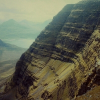
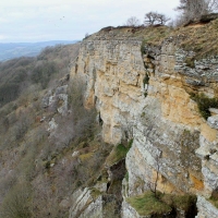
The GR10 (Grande Randonnée – Grand Ramble – the French long-distance footpath network) is to take me from Lescun towards Refuge de l’Abernouat. So I’m off up this pleasant cart track, with the village below me and Dino and his mates making sure people don’t sleep too late. I pass through hay meadows wet with dew and studded with alpine flowers, to the sound of cowbells ringing in the valley. And before me, the God-awful ramparts of Le Billare thrust from the forests in a fantastically impossible wall of limestone. This is the wall of rock I glimpsed through the mist last night. Now it is revealed in its splendour. And very daunting it is, too. Behind it, still shrouded from view, is my target for the day, the 2,504-metre Pic d’Anie (below) – which works out at 8,218ft, the highest mountain I have climbed so far. If I get to the top of it, that is.

Pic d'Anie
Actually, I could have driven up to the refuge but I chose to take the path. In retrospect, it would have made life easier. But what the heck. On the GR10 I see a farmer milking sheep in a field where what appears to be an old yellow Ford Anglia Estate is parked in a mud hole, and I pass through some very pleasant meadows, the sort you picture if you think of Heidi, but it adds one-and-a-half hours of walking and a considerable height to the day’s total.
There’s a lot of building work going on in the Refuge de l’ Abarouat, so I have a swig of water and pass on by. I follow the GR10 (which is waymarked with red and white slashes of paint on boulders) into thick woodland, ascending all the time, and think I hear bears – which puts the willies up me. Pyrenean bears are extremely rare and avoid contact with man. That’s not to say a particularly angry and hungry one is not going to blunder out of a bush and eat me. Had a nasty scare in the Tatras a few years ago concerning bears. At least I think it was bears.
Eventually I emerge into brilliant sunlight in a high alpine meadow and directly below Cabane d’Ardinet. Four or five athletic looking Frenchmen all dressed in red emerge from the cabane, salute me with bon jours, and head off towards the impossible ramparts of Pic de Countende, which is over to my left. I try to work out their route up it but I can’t. It looks impossible to climb – unless you’ve got a bear chewing your ankles.
 In almost no time at all, I reach Cabane Cap de la Baitch (right), which is deserted so I look inside. My God, there is a stainless steel sink with mixer taps, a grand wood-burning stove, and a generator locked in a sideroom. There’s a snug sleeping platform up a ladder above the kitchen, a big dining table, and little windows with shutters. This is at an altitude of 1,689 metres (a good deal higher than Ben Nevis) – the most luxurious bothy indeed. Knocks the spots off Callater Lodge, and I thought THAT was luxurious.
At the cabane I leave the GR10, which snakes north over Pas d’Azuns, and I head off towards Col des Anies, which looks straightforward on my map – but the path is not waymarked and route finding becomes frustrating work. My guidebook talks of impressive karst limestone formations, but on the col I am in a limestone wilderness of huge, undulating ridges cleft with snow-filled gullies and totally devoid of soil or vegetation. It is, almost literally, a sweeping moonscape of barren rock from which the surrounding peaks thrust seemingly vertically. There are few paths, because you can’t wear a path across barren rocks. But I notice that, occasionally, rocks are marked with a splodge of purple or red paint and there are attempts at tiny cairns. These sort of guide me in a very uncomfortable and unconvincing manner to a point where I join a good path slicing across the wilderness from Spain.

Karst wilderness of Col des Anies, with Pic du Soum Couy
This new path is the HRP, the high-level, long-distance footpath that traverses the Pyrenees from the Atlantic to the Mediterranean. There are several long-distance paths that traverse the range, but the HRP is the highest and hardest, and having had a taste of it I can say with all honesty that it’s certainly for hardier souls than me. The GR10 also makes the traverse, though keeps beneath the high peaks and visits the valleys, and I do believe there’s an equivalent on the Spanish side.
The HRP offers, in places, several optional routes, and one of these leads conveniently to the summit of Pic d’Anie. The route is marked with double yellow splodges of paint. I am now following red splodges, purple splodges and yellow splodges. This makes me feel more secure. Though I must emphasise that these splodges are few and far between, and I really have to keep alert to spot them, especially where the path crosses bare sections of rock and to all intents and purposes disappears entirely.
Rising above this wilderness, the Pic du Soum Couy lifts impressively to the north, with the Pic de Countende to my south-east and the Pic d’Anie to the south. Did I mention that I’ve got to circumnavigate Anie to climb it? No, I don’t think I did. The only walker’s route rises from the north flank across its northern screes, goes right round the west flank and to the south face before doubling back to make a bid for the summit. On the upside, once in the screes (which fall from vertical white limestone walls) the path is good and easy to follow. But there is a downside. There are five or six gullies filled with snow, all dropping several hundred feet at steep angles – and they have to be crossed.

Pic du Soum Couy above Lescun
I flounder across three or four of them – gingerly – following in someone else’s footprints, and meet my first fellow walker of the day, who is returning from the summit. I greet him in French; he greets me in Spanish; I tell him I am English and can speak neither French nor Spanish; he tells me he is German and asks if I know any Deutch. Like a fool I say “eine bisschen”, and he launches into a speech in which the only word I can discern is schnee – which I presume is German for snow. But he has been to the top and says: “Es ist gut.”
I cross another snowfield, wondering what all the fuss is about and quite impressed by the fact that, in the space of 20 seconds, I have met a complete stranger and conversed in four major European languages. Then I come to steep, hard rock, and for a while the ascent becomes very hands-on up limestone walls. The guidebook doesn’t say anything about scrambling.
 Then I reach the final snowfield, which is wide and steep, and offers the unwary the opportunity to slide several hundred feet into Spain. This must have been what the German was telling me about, I reason. It looks just a little too dangerous to tackle without an axe, so I opt for the “safe” route and climb above it on the scree and rock. This I accomplish with no small amount of difficulty, regain my waymarked path (and extremely comforting red, purple and yellow splodges), and after a few steep and breathless zigzags arrive on the summit.
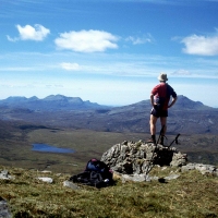
The summit is small and the view incredible. This is a proper mountain peak, compact and rocky, with panoramic vistas to astound and entertain. I take loads of pictures, all of which give absolutely no impression of the vast scale of these mountains.
A young Spaniard arrives on the summit, carrying a wooden staff instead of trekking poles – like an alpine staff, I suppose. I say “adios” and disappear over the edge, dropping back towards the upper snowfield, which I am determined to cross this time. But my nerve goes, and again I take to the screes for an uncomfortable descent.
The snowfields seem more dangerous going down and I am not happy crossing them. I tread very carefully, in fear I might slip and end up far below and in several pieces. When I have only three snowfields left to cross, the Spaniard with the staff passes me. He enters the next snowfield like he’s on a Sunday stroll, sloshing across like nobody’s business. “That’s the way to do it,” I say to myself. All you need is a bit of confidence and a big stick. And I trundle across in no time.
Doddle these snowfields. Really don’t see what all the fuss is about.

View from the summit of Pic d'Anie


*grins* Love the ice axe bit. Why is it that people always assume any equipment you take is a bare minimum to give you a slight chance of avoiding imminent death, instead of a sensible safety precaution?
Mind you, I’m not convinced that my ‘extra bar of kendal mint cake’ convinces anyone I’m risking life and limb if I’m off for a wander around Buttermere…
LikeLike
I hated the snow patches – My trip in the Pyrenees took place in June – and I always seemed to encounter them when I was going down hill, late in the afternoon when it looked like it was about to pee down with rain and thunder & lightning. Thinking about it, yes – there were more down hill snow patches than uphill. How can that be?
🙂
LikeLike
And another thing about snow patches is when you’re crossing them they seem as steep and as deadly as hell – but if you take a picture of them they look like gentle slopes you’d push your kids down on a sledge.
LikeLiked by 1 person